

1. Key Laboratory of Digital Earth, Aerospace Information Research Institute, Chinese Academy of Sciences, Beijing 100094, China
2. International Centre on Space Technologies for Natural and Cultural Heritage under the auspices of UNESCO, Beijing 100094, China
Summary:
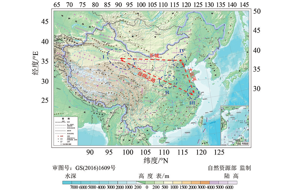
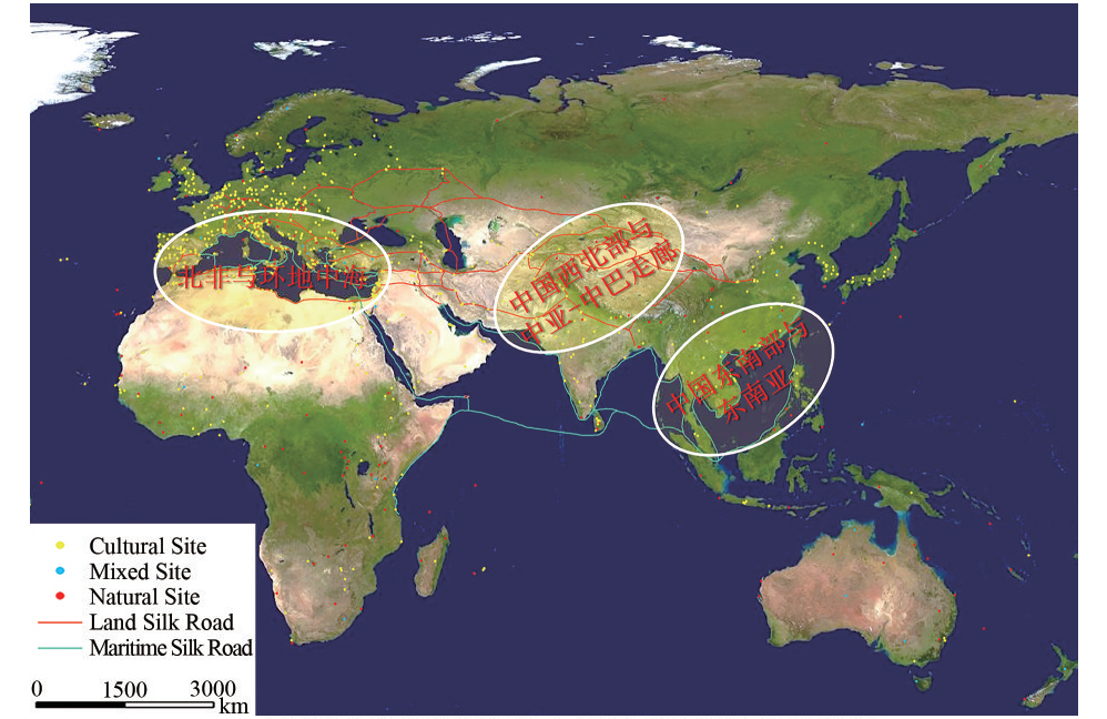
In the past century, remote sensing has been of particular interest for archaeological specialists and the public because of the combination of three key points of archaeologicalresearch objects, space, and time. Remote sensing has become an important and powerful tool for helping archaeologists to explore and understand cultural and archaeological sites, discovering and monitoring archaeological sites, documenting and preserving cultural heritage, and resolving real archaeological problems. Recently, the focus of remote sensing-based archaeological applications has moved away from survey, mapping, monitoring, and documentation to the deep-mining of archaeological big data, archaeological knowledge (re-) discovery and understanding, and settlement pattern analysis and archaeolandscape reconstruction. These improvements and transformations have been jointly pushing remote sensing archaeology toward a new stage of space archaeology. In this study, the major achievements in remote sensing that is used for cultural heritage conservation are reviewed. Then, a brief dissection of connotations, tasks, methods, and potentials of the new paradigm of space archaeology is provided. The research object of space archaeology is the culture–space or human–land complex containing the remains of anthrophonic production, living activities, and their supporting eco-environments. Space archaeology, a new subfield of archaeology, has the technical advantages and disciplinary characteristics of shaping the unique cognition of cultural heritage. Space archaeology represents an invaluable set of powerful tools for prospecting, monitoring and documentation. It also supports the conservation of archaeological and cultural heritage sites and their supporting environments. The establishment and construction of space archaeology need experimental areas and bases. On the one hand, this study presents the layout of the experimental areas of “three lines and four zones” for domestic research on the basis of the comprehensive consideration of the occurrence conditions of cultural heritage sites in China, the characteristics of human production and living activities that took place in the sites, and the adaptability and differences of methods and approaches in space archaeology. The three lines are the Grand Canal, the Great Wall, and the Silk Road. The four zones are the desert environment in northwest China, the semi-humid valley landscape in central China, the wetland landscape in south China, and the farming-pastoral ecotone in northeast and northwest China. On the other hand, three international experiment areas are given priority for carrying out the demonstrations of space archaeology based on historical, natural and cultural, social and economic backgrounds and the current physical geographical conditions of Eurasia and Africa. These experimental areas are Southeast China and Southeast Asia, Northwest China and Central and South Asia, North Africa, and the Mediterranean Regions. The delimitation of these experimental areas contribute to the integration and cross innovation of different disciplines in the fields of culture, science, and technology. On the basis of the analysis of the research progress and current development of spatial information technology, this study puts forward the cognition from remote sensing archaeology to space archaeology and describes the connotation of space archaeology, the main research content, and the suggestion on domestic and international experimental regions. Space archaeology not only discusses with the need to adapt to the new tasks, new development, and new disciplines under the era of conservation and sustainable development of cultural heritage. It also deals with the requirement and mission of culture, science, and technology to promote the construction of “One Belt and One Road” and to contribute to improving the soft-power of participating in global governance. Space archaeology should contribute its unique strength and value to the conservation and development of cultural heritage in the new era.


Journal of Remote Sensing
Wang X Y and Luo L. 2020. From remote sensing archaeology to space archaeology: A new task in the era of cultural heritage protection. Journal of Remote Sensing(Chinese),24(7): 837-841[DOI:10.11834/jrs.20200016]
upported by Strategic Priority Research Program of the CAS (No. XDA19030502); National Natural Science Foundation of China (No. 41801345)
Copyright © 2026 International Centre on Space Technologies for Natural and Cultural Heritage under the auspices of UNESCO.
Beijing ICP Filing No. 05002788-3


